Most of the forts in India are actually castles or fortresses. But when the British Government in India were cataloging them in the 17th–19th century they used the word forts as it was common in Britain then. All fortifications whether European or Indian were termed forts. Thereafter this became the common usage in India. In local languages, the fort names are suffixed by local word for fort thus usage of the Sanskrit word durga, or Urdu word qila or the Hindi word garh or gad in Rajasthan, and Maharashtra is common.
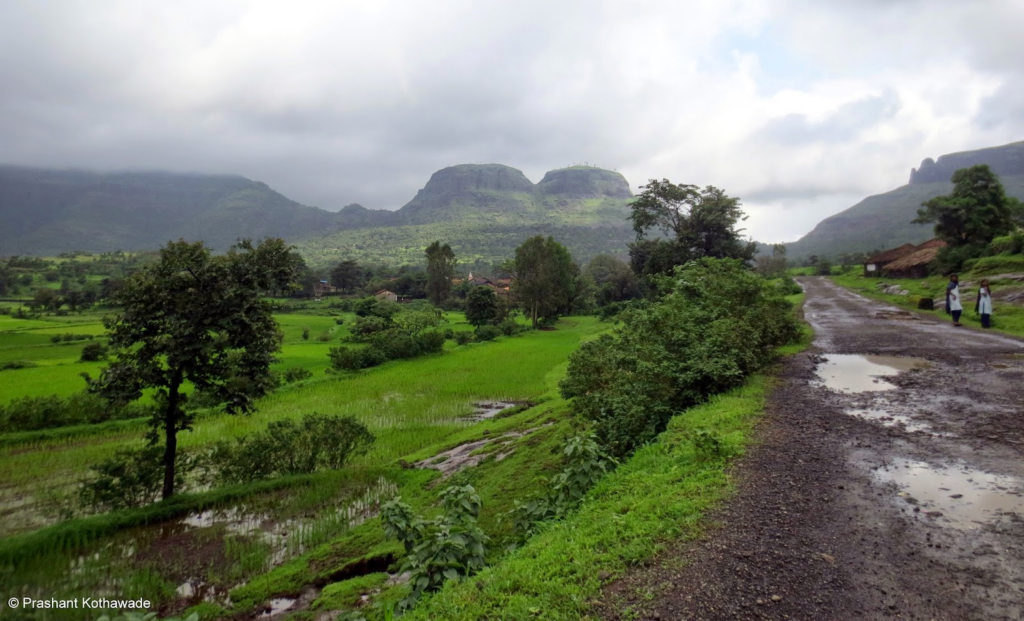
There are Nine forts in Junnar. The list of this forts are Shivneri, Chawand, Narayangad, Hadsar Nimgiri, Harischandragad, Sindola, Kunjirgad and Zivdhan etc.Shivneri is located in Junnar itself. Chawand is to the west side of Junnar. Narayangad is to near of GMRT, Khodad. Harishchandra gad is located at the point where boundaries of 3 Districts are come together i.e.Pune, Ahmadnagar and Nashik etc. Hadsar Nimgiri, Sindola and Kunjirgad are located in Sahyadri valley.
These all forts can be easily accessible via road, Railway and by Air. Nearest railway stations are Pune, Ahmednagar Nashik and Kalyan etc. Pune is the only nearest airport to reach these forts.
Forts
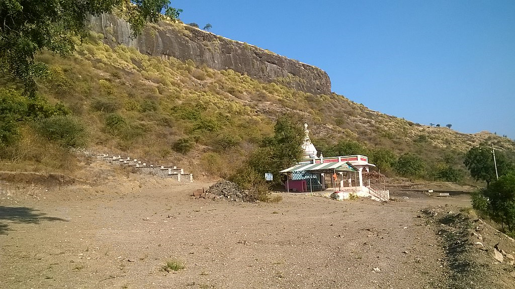
1. Shivneri
Type of Destination: Trekking, Fort, Monument
Languages Spoken: Marathi & Hindi
Open Time: Day Time Only
Ideal Trip Duration: 3-4 Hours
Fort Altitude: 918m
About Shivneri Fort
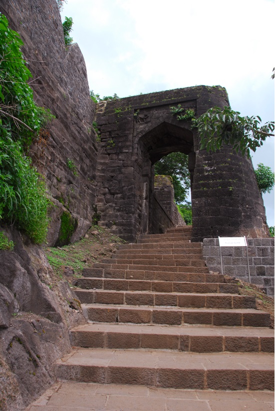
The birth place of renowned Maratha King Chhatrapati Shivaji Maharaj, Shivneri Fort is located near Junnar in Pune district of Maharashtra. The fort which dates back to 17th century used to be a military bastion. Perched on a hill top Shivneri Fort is visible all the way from Junnar town itself.
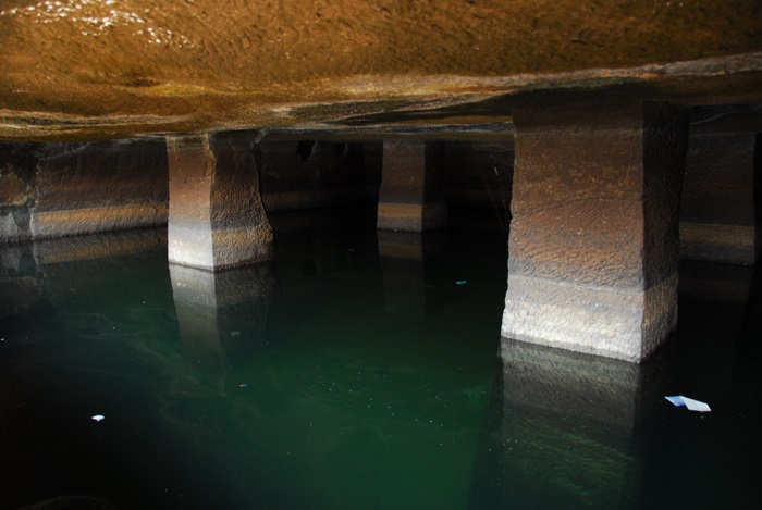
From 1716 to 1820, the place was controlled by Maratha Empire. From 1820-1947, the place got under the control of British Raj, and after 1947 till now the place is under the Government of India.The presence of habitation can be acknowledged from the caves, the rock-cut architecture and the water system. It is believed that the place was dominated by the Buddhists under their rule in 1st century A.D. Shivneri was basically under the possession of Yadavas and Devagiri and that’s where it got its name from. One can see the fort is well protected by steep rocky terrain on four sides. Inside the Shivneri Fort, there is a small shrine for Goddess Shivai Devi, from whom the Maratha King got the name Shivaji. In the center section of the fort, we can come across water pond. Also the two water springs namely Ganges and Yamuna inside the fort are perennial.
Shivneri Fort is a nice day trip option from both Mumbai and Pune. Malshej Ghat is only 28 km further from Shivneri. MSRTC also operates Volvo bus service to this town from major cities of Maharashtra.
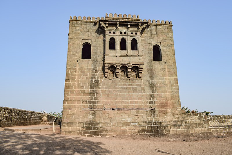
Shivneri is a hill fort having a triangular shape and has its entrance from the South-west side of the hill. Apart from the main gate there is an entrance to the fort from side called locally as the chain gate, where in one has to hold chains to climb up to the fort gate. The fort extends up to 1 mi (1.6 km) with seven spiral well-defended gates. There are mud walls all around the fort. Inside the fort, the major buildings are the prayer hall, a tomb and a mosque. There is an overhanging where executions took place.[2] There are many gates structures protecting this fort. Mana Daravaja is one of the many gates of the fort.
At the centre of the fort is a water pond which is called ‘Badami Talav’, and to the south of this pond are statues of Jijabai and a young Shivaji. In the fort there are two water springs, called Ganges and Yamuna, which have water throughout the year. Two kilometers away from this fort there are the Lenyadri caves which is one of Ashtavinayak temple in Maharashtra. It has been declared as a protected monument.[3] (Ref Wikipedia)
2. Chawand
Type of Destination: Trekking, Fort, Monument
Languages Spoken: Marathi & Hindi
Open Time: Day Time Only
Ideal Trip Duration: 3-4 Hours
Fort Altitude: 619 meters
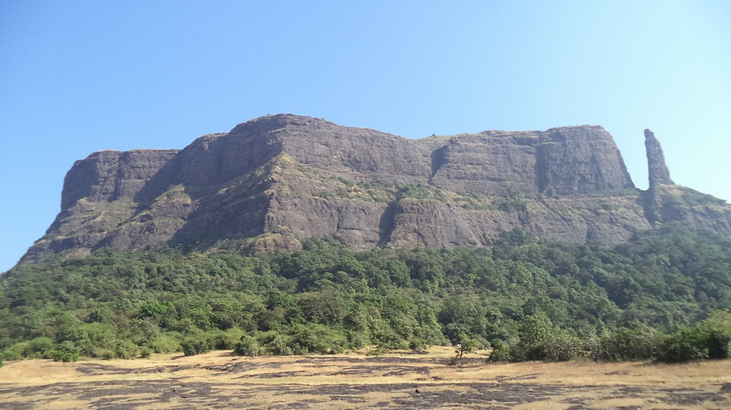
About Chawand Fort
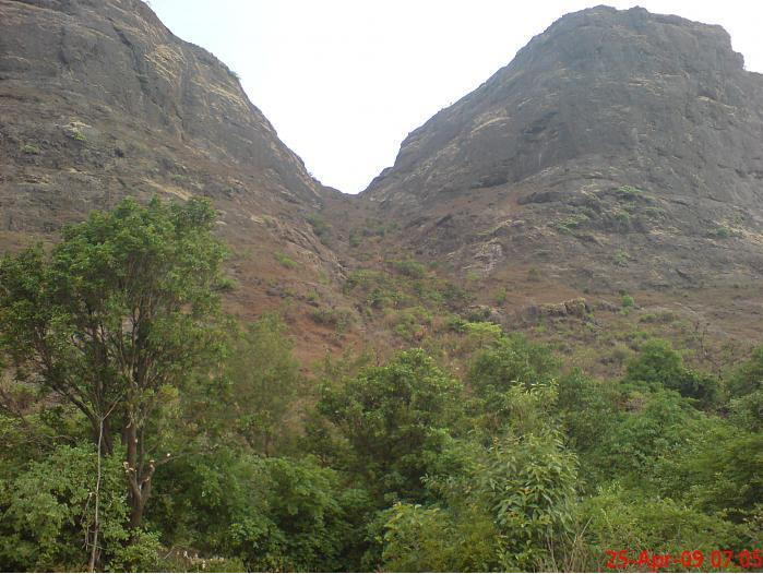
Cha’vand is a ruined and dismantled fort ten miles north-west of Junnar and ten miles south-east of the Nana pass. The road from Junnar to Chavand runs through a valley between two ranges of hills one with Hadsar fort stretching to the north-west and the other with the forts of Chavand and Jivdhan running to the southwest. These three forts, and Shivner at the south-east end of the Nana pass valley, effectually guarded the Nana pass and preserved a safe communication between Junnar and the Konkan. The chief strength of Chavand lies in its great natural defences. Its artificial defences, which were weak and incapable of holding out against a hostile force, were all destroyed and the approach to the fort blown up about 1820. Except to hill men the hill is now inaccessible. Near the summit is a deep and narrow precipice which cannot be climbed except with a rope. On the plateau is a small shrine dedicated to the goddess Chavandbai. The water-supply is good but other supplies are scarce. In 1486 Chavand was among the Poona forts which fell to Malik Ahmad the founder of the Ahmadnagar Nizam Shahi family. [Briggs’ Ferishta, III. 190.] In 1594 Bahadur the infant son of Burhan Nizam II. (1590-1594) was confined in Chavand for over a year and was then raised to the Ahmadnagar throne. [Briggs’ Ferishta, III. 304.] In 1637 Jund or Chavand appears among the Poona forts which Shahaji gave to the Moghals. [Elliot and Dowgon, VII. 60; Grant Duff’s Marathas, 53.] In the Maratha war of 1818 a British brigade was sent to take Chavand. The brigade encamped before; Chavand on the 1st of May 1818 and demanded its surrender. The commandant refused to surrender unless directed by his master. A fire of mortars and howitzers was begun in the evening and the bombardment continued till next morning during which about a hundred shells were fired. Then the garrison of upwards of 150 Marathas surrendered unconditionally. They were disarmed and dismissed to their villages. [Pendhari and Maratha War Papers, 294.]
Reference: https://gazetteers.maharashtra.gov.in/cultural.maharashtra.gov.in/english/gazetteer/Poona%20District/places_j.html#. dATED 27.07.2020
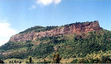
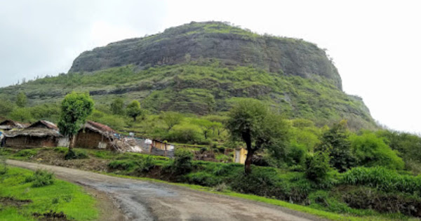
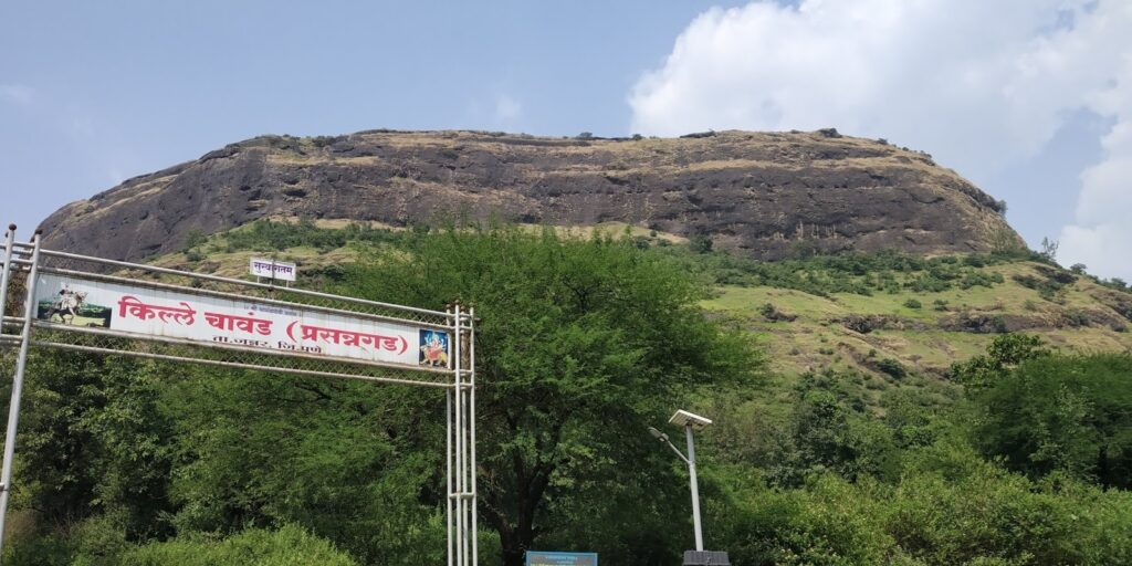
chavand ( Marathi: चावंड किल्ला) is a hill fortress situated 30 km from the modern-day town of Naryangoan in Junnar Taluka of Pune district in Maharashtra, India. The fort, which rises 1,036 meters (3,399 feet) above sea level, is located in the Sahyadri mountain range. The fort was looted and destroyed by the British upon siege. This is one of the forts known as the ‘Famous 5’. Chavaand, Hadsar, Shivneri, Jivdhan and Naneghat form the Famous 5 trek. The fort has remnants of construction that are more than 800 years old. Village of Chavandwadi lies at the base of the fort. Under the rule of Shivaji this was known as Prasannagad.
History
Founder of Nizam Dynasty, Nizam Ahmed was the first Nizamshah who acquired the fort of Chavand after the dissolution of the Bahmanid Empire. The seventh Nizamshah was Burhanshah II. Bahadurshah’s grandson was imprisoned 1594 and was taken away to this fort.[1] Bahadurshah is the nephew of Chandbibi. In 1636, the Mughals got the fort of Chavand by signing a treaty with the Nizams. On 1 May 1818 the British forces captured the fort [2]
Geography
Chavand fort is approximately 20 km away from the city of Junnar in Pune district and is a popular destination for trekkers and adventure enthusiasts. There is a varied flora and fauna around the foothills of the Chavand fort trek. There are 12 various species of birds to observe. The base village of the Chavand Fort is Chavandwadi village.
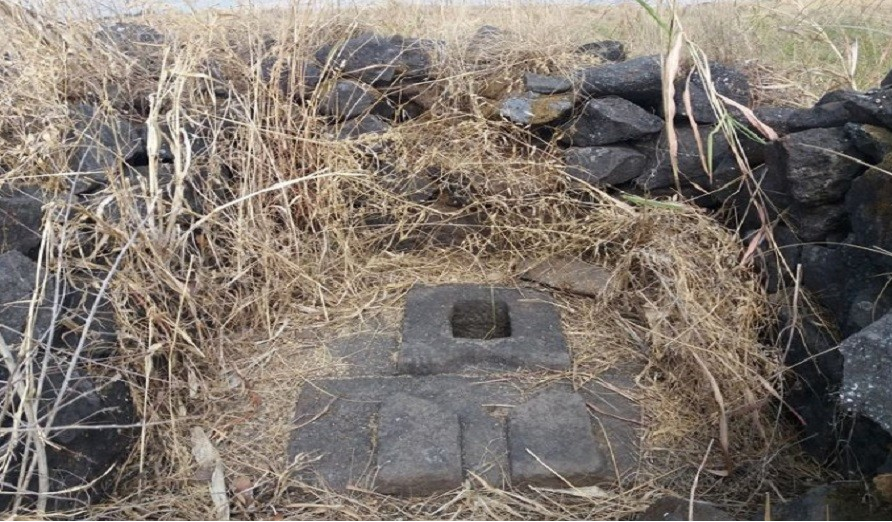
There is a huge stone door called the Mahadarwaja which is still structurally intact. There is a Chamunda Devi Mandir on the fort along with a few remnants of a cannon as well. There are seven water tanks carved out of a single stone. The top of the fort offers splendid views of the neighbouring regions along with views of forts like Shivneri, Jivdhan and Hadsar. One can also see the seven tanks, the Kukadi river and the Manikdoh dam. [3](Ref Wikipedia)
जुन्नर तालुक्यामध्ये नाणेघाटाचे पहारेकरी म्हणून नावलौकिक मिळवलेले किल्ले म्हणजे जीवधन, चावंड, हडसर, शिवनेरी आणि नारायणगड. यांपैकी चावंडकिल्ला जुन्नर शहरापासून तासाभराच्या अंतरावर असलेल्या आपटाळे गावानजीक आहे. गडाच्या पायथ्याशी चावंड गाव वसलेले आहे. नाणेघाटापासून जुन्नरच्या दिशेने १५ कि.मी च्या आसपास चावंड वसलेला आहे.
- स्थळ : चावंड ता.जुन्नर जि.पुणे
- किल्ल्याची ऊंची : 3400 फूट
- किल्ल्याचा प्रकार : गिरीदुर्ग
- डोंगररांग : नाणेघाट
इतिहास
- सन १४८५ मध्ये अहमदनगरच्या निजामशाहीची स्थापना करणार्या मलिक अहमदला पुणे प्रांतातले जे किल्ले मिळाले, त्यामधे चावंडचे नाव आहे. बहमनी साम्राज्याचे जे तुकडे झाले, त्यात त्याला उत्तर कोकण व पुणे प्रांत मिळाले.
- दुसरा बुह्राण निजामशाह (इस १५९०-१५९४) हा सातव्या निजामाचा नातू . बहादुरशाह १५९४ साली चावंडला कैदेत होता
- १६३६ मध्ये निजामशाहीचा आदिलशाह आणि मोगलांपासून बचाव करण्यासाठी शहाजीराजांनी जो तह केला, त्यानुसार चावंड मोगलांना मिळाला.
- मे १६७२ पर्णाल पर्वत ग्रहणाख्यानात कवी जयराम पिंडे म्हणतो की,. त्याचप्रमाणे चामुंडगड, हरिश्चंद्रगड, महिषगड आणि अडसरगड हे किल्ले महाराजांच्या मावळ्यांनी जिकिरीने लढून घेतले. महाराजांनी याचे नाव प्रसन्नगड असे ठेवले.
- या गडाची अनेक नावे अशाप्रकारे आहेत; चामुंड, चाऊंड, चावंड ही नावे चामुंडा या शब्दाचा अपभ्रंश आहेत चुंड हे निजामशाही आमदानीतील नाव आहे.
- प्रसन्नगड हे शिवाजी महाराजांनी ठेवलेले नाव.
- मलिक अहमदने शिवनेरी जिंकल्यावर आपल्या एका सरदाराच्या हाती हा किल्ला दिला. या किल्ल्यातही भरपूर लूट त्याच्या हाती आली. किल्ल्याची व्यवस्था आपल्या एका सरदाराच्या हाती सोपवून त्याने लोहगडाकडे आपला मोर्चा वळवला.
संदर्भ
अहमदनगरची निजामशाही
मलिक अहमदच्या अधिकारापुढे नमूद केलेल्या किल्ल्यांच्या अधिकार्यांनी मान झुकवली नव्हती. त्यांचा पाडाव करण्यासाठी त्याने कूच केले. ते किल्ले म्हणजेचावंड, लोहगड, तुंग, कोआरी, तिकोणा, कोंढाणा, पुरंदर, भोरप, जीवधन, मुरंजन, महोली आणि पाली हे सर्व किल्ले त्याने बळाचा वापर करून आपल्या ताब्यात घेतले. गुलशने इब्राहिमी आदिलशाहच्या सैन्याशी लढताना इब्राहीम निजामशाहच्या मस्तकात गोळी लागून तो ठार झाला. निजामशाही वकील मिया मंजू याने अहमद नावाच्या मुलाला दौलताबादच्या कैदेतून सोडवून गादीवर बसवले. त्याचवेळी त्यांने इब्राहीमच्या अल्पवयीन मुलाची म्हणजे बहादूरशाहची चावंडला बंदिवासासाठी रवानगी केली चांदबीबी ही बहादूरशाहची आत्या. मिया मंजूने बहादूरशाहवर असलेले चांदबीबीचे पालकत्व हिरावून घेतले. पुढे निजामशाही गादीवर तोतया आहे, हे सिद्ध झाले निजामशाही सरदार इख्लासखान याने चावंड किल्ल्याच्या सुभेदाराला, राजपुत्र बहादूर याला आपल्या हवाली करण्यास हुकूम पाठवला. या हुकुमाचे पालन मिया मंजू याच्या लेखी आज्ञेशिवाय होणार नाही असे सुभेदाराने कळवले. इख्लासखानाने तोतया बहादूरशहा निर्माण केला. मिया मंजूने अकबराचा राजपुत्र मुराद यास मदतीस बोलावले. मुराद अहमदनगरच्या किल्ल्यावर चालून आला. आता मिया मंजूला पश्चात्ताप झाला त्याने अहमदनगरच्या संरक्षणासाठी सरदार अन्सारखान व राज्यप्रतिनिधी म्हणून चांदबीबीला नेमले. मिया मंजू आदिलशाह व कुतुबशहा यांना मदतीस बोलावण्यास अहमदनगरच्या बाहेर पडला. चांदबीबीने याचा फायदा उठवीत त्याचा हस्तक अन्सारखान याचा खून करवला आणि चावंडच्या अटकेतून बहादूरशाहची मुक्तता करत त्याची सुलतान म्हणून ग्वाही दिली.
- चावंड हा चामुंडा नावाचा अपभ्रंश असल्याने व त्यावर पाणयाची सात टाकी एकाच ठिकाणी असल्याने तो सप्त मातृकांशी संबंधित आहे म्हणून तो शाक्त पंथाशी निगडित आहे.
- चावंड निजामशाहीत जाण्याअगोदर तेथील किल्लेदार महादेवकोळी जमातीतला असावा. असे तेथील स्थानिक महादेवकोळी वस्तीवरून प्रतीत होते. येथील अवशेषांना पाहता आणि राजमार्ग अभ्यासता चावंड सातवाहनकालीन असल्याची चिन्हे दिसतात. निजामशाही वारसदाराला येथे ठेवण्यासाठी या किल्ल्याचा वापर केला गेला. यावरून त्याची दुर्गमता दिसून येते. त्याचा इतिहास बखरींच्या पानांत नसला तरी मौखिक लोकसाहित्यात नक्की सापडेल.
- चामुंडा हे देवीचे क्रूर रूप , या रुपात सर्व काही भयानक, अमंगल ही देवी बंगाल, बिहार, उत्तर प्रदेश, राजस्थान येथील आहे. हाडकुळी, जीभ बाहेर, उभे केस, मुंडांच्या माळा, हाडांचे दागिने, व्याघ्रचर्म नेसलेली स्मशानात पिंपळाखाली हिचे वास्तव्य. हिचे वाहन गाढव, प्रेत, घुबड, गिधाड ध्वजावर अग्नीपुराणाप्रमाणे चार हात शक्ती, मुंड, शूळ ही हिची आयुधे.
- सप्त मातृका म्हणजे ब्राम्ही, महेश्वरी, कौमारी, वैष्णवी, वाराही, इन्द्राणि आणि चामुंडा या सर्वांमध्ये चामुंडा श्रेष्ठ मानली जाते. – संदर्भ देवी भागवत
पहाण्याची ठिकाणे
दरवाजातून आत जाताच, दहा पायर्या चढून गेल्यावर दोन वाटा लागतात. वरची उजवीकडची वाट उद्ध्वस्त अवशेषांकडे घेऊन जाते, तर डावीकडे तटबंदीच्या बाजूने जाणारी वाट आहे. उजव्या बाजूस कातळात कोरलेल्या १५ – २० पायर्या चढून गेल्यावर, काही वास्तू नजरेत येतात. एका वास्तूचा चौथरा अजून व्यवस्थित आहे. इथे आपल्याला अशा बर्याच वास्तू दिसतात जवळ (जवळ १५ ते २० वास्तूंचे अवषेश इथे आहेत) , म्हणून असा निष्कर्ष काढता येइल की इथे मोठी वस्ती असावी. आजुबाजुच्या परीसराचा मुलकी कारभार या गडावरुन चालत असावा. जेथे चौथरा शिल्लक आहे. जाणकारांच्या मते हा चौथरा म्हणजे या किल्ल्याची सदर असावी. किल्ल्यावरील सदर असलेला हा चौथरा मातीने पूर्णपणे गाडला गेला होता. मात्र गेली वीस वर्षे गड संवर्धनाचे काम करणाऱ्या शिवाजी ट्रेल या संस्थेच्या वतीने व याच संस्थेचा भाग असणाऱ्या हिस्ट्री क्लब या संस्थेने हा सदरचा चौथरा व चावंड किल्ल्यावर गेली पाच वर्षे संवर्धनाचे कार्य केल्याने अनेक वस्तू उजेडात आल्या आहेत. किल्ल्याची सदर असलेल्या चौथार्यासमोर दोन मोठी गोल दगडी पाणी साठवण टाकी आहेत. मात्र त्यास खालच्या बाजूला एक-एक छिद्र आहे. जवळच मुख्य राजवाड्याचा चौथरा आहे. बाजूलाच २ संलग्न अशी टाकी आहेत. येथून उत्तरेस थोडे पुढे गेलो की एक खचत चाललेली वास्तू नजरेस पडते. पण बरीच खचल्यामुळे जास्त काही अंदाज बांधता येत नाही. येथून आजूलाबाजूला साधारण ३०० मी. च्या परिसरात १० -१५ उद्ध्वस्त बांधकामे तशीच ७-८ टाकी आढळून येतात. गडाच्या याच भागात बर्यापैकी तटबंदी असून, आग्नेय भाग कड्यांनी व्यापला आहे. ज्या भागात तटबंदी आहे, त्या भागात या तटबंदीच्या बाजूने फिरण्यास जागा आहे ही बहुदा गस्त घालण्यासाठी असावी. या ठिकाणी बराच उतार असून काही ठिकाणी हौद आहेत.
थोडे पुढे उजवीकडे गेल्यावर एका मंदिराचे (पुष्करणी पद्धतीचे मंदिर) अवशेष आढळतात. येथेही बरेच शिल्पकाम आढळते. गडाच्या वायव्य भागात एकमेकांना लागून अशी सात टाकी आहेत, ही टाकी सप्त मातृकांशी निगडित आहेत.
ज्या ठिकाणी तटबंदी ढासळलेली आहे, तिथे चिर्याचे दगड गडग्यासारखे रचून ठेवले आहेत. हे कोणाचे काम असावे हे कळत नाही. इशान्य भागात ज्या ठिकाणी तटबंदी संपते, त्या ठिकाणी कातळकोरीव गुहा आहेत. या पहारेकर्यांच्या चौक्या असाव्यात. एक गुहा अगदी सुस्थितीत आहे. गुहेत प्रवेश केल्यावर दोन्ही बाजूला हौद सदृश साधारण ५ फूट खोलीचे बांधकाम आढळते. या गुहेलगत असलेल्या तटबंदीच्या खाली भुयारी मार्गाचे प्रवेशद्वार आहे असे ग्रामस्त सांगतात, येथे रॅपलिंग करून जाता येते. यापुढे आपण गडाच्या पूर्वेस येतो. या भागात कोणतेही अवशेष नाहीत. बेलाग कड्यांनी हा भाग व्यापला असल्यामुळे इथे तटबंदी नाही. हा भाग बराच विस्तीर्ण असूनही निर्जन आणि ओसाड आहे. जवळ जवळ अर्ध्या किमीच्या परिसरात एकही बांधकाम आढळत नाही. गडाच्या दक्षिण बाजूला आणि नैऋत्येस आपल्याला तुरळक अशी तटबंदी आढळते. इथेच पाण्याची दोन टाकी आहेत. इथून पुन्हा पश्चिमेकडे निघाल्यावर आपल्याला मजबूत अशा तटबंदीचे दर्शन घडते. दोन बुरूजही आढळतात इथून आपण टेकडी कडे निघतो, मंदिर पाहायला.
गडाच्या सर्वात उंच भागात चामुंडा देवीचे मंदिर आहे. मंदिरातील मूर्ती प्राचीन असून बांधकाम मात्र नवीन आहे. आजुबाजूला जुन्या मंदिराचे अवशेष विखुरलेले दिसतात. एक तुटलेली मूर्ती आढळते, जी एखाद्या ऋषीचे प्रतीक असावी. तसेच एक आश्चर्यकारक गोष्ट म्हणजे या चामुंडा देवीच्या मंदिरासमोर आढळणारा नंदी . जुन्या अवशेषांमध्येही नंदीची मूर्ती आढळते. याचा अर्थ हा होतो की जवळच कुठेतरी शिवलिंग असावे आणि काळाच्या ओघात हरवले असावे. ग्रामस्थांनी श्रमदानाने जसे नवीन देऊळ बांधले तशी शेजारी असलेली दीपमाळही बांधण्याचा प्रयत्न केला आहे. ही दीपमाळ असे सुचवते की इथे एक शिवमंदिर असावे.
एकंदरीत पाहता, गडाचा घेरा विस्तीर्ण आहे. साधारण ५ – ६ किमीचा परीघ असावा. गडाच्या इशान्येस असणार्या गुहांचा अभ्यास होणे महत्त्वाचे आहे. या वास्तूंविषयी बर्याच दंतकथा प्रचलित आहेत. गडावर सातवाहन संस्कृतीचा प्रभाव आहे. या किल्ल्यांचा इंग्रजांनी पूर्ण नायनाट करण्याचा प्रयत्न केला, पण ते सफल झाले नाहीत. आज हेच किल्ले आपल्याला आवाहन करीत आहेत, त्यांना भेट द्यायला, तर का आपण जाऊ नये? इथल्या स्थानिक महादेवकोळ्यांकडून जसे आपण दंतकथा ऐकतो, तसे इतिहासही जाणून घेण्याचा प्रयत्न करूया.
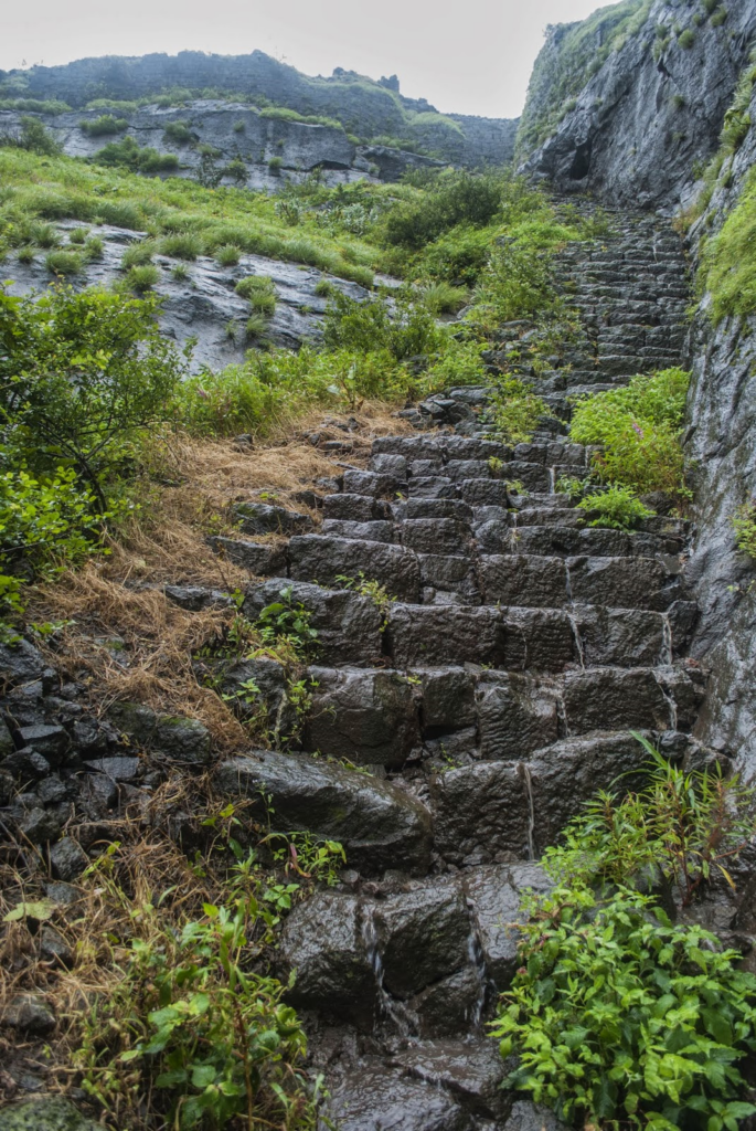
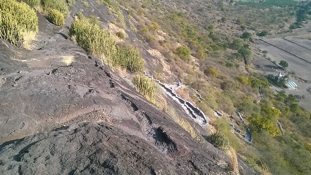
गडावर जाणार्या पायर्या अगदीच छोट्या आहेत. इंग्रजांनी १ मे १८१८ रोजी चावंडवर हल्ला करून येथील पायर्या उद्ध्वस्त करून टाकण्याचा प्रयत्न केला. तशा सुरुंग लावल्याच्या खुणाही आपल्याला पायर्या चढताना दिसतात. पूर्वी येथे जाणे येणेही पूर्णपणे औघड होते. मात्र शिवाजी ट्रेल या संस्थेने गेली पाच वर्षात केलेल्या गड संवर्धन कार्यामुळे व त्याला वनखात्याच्या मिळालेल्या प्रतिसादामुळे किल्ल्यावर जाणारा पायरीमार्ग व्यवस्थित झाला आहे. वर चढून गेल्यावर प्रथमदर्शनी नजरेस पडते ती कातळकोरीव गणेशप्रतिमा, आणि नैऋत्यमुखी प्रवेशद्वार. या प्रवेशद्वारावरही एक गणपती कोरलेला आहे. यावरून असे कळते की पेशवे काळातही या गडावर बराच राबता असावा. दरवाजाची उजवी बाजू म्हणजे एक अखंड कातळ आहे. उजवा स्तंभही याच कातळातून कोरलेला आहे. गडावरची हीच वास्तू अबाधित राहिली आहे.
Reference : http://www.junnartourism.com/forts/chavand/
3. Narayangad
Type of Destination: Trekking, Fort, Monument
Languages Spoken: Marathi & Hindi
Open Time: Day Time Only
Ideal Trip Duration: 3-4 Hours
Fort Altitude: 2557 feet
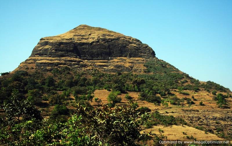
About NARAYANGAD
About three miles east of the town Narayangoan on a detached hill which on the north, south, and west rises sharp from the plain is the dismantled fort of Narayangad. Narayangad is a hill fort near Pune, located 80 km from Pune, 8 km from Narayangaon and 5 km from Khodad village. Near Narayangad is a small village named Gadachiwadi. Narayagoan is derived from the fort. From the base of the fort to the top of the fort is an easy climbing of twenty minutes.
Also the bus available from Narayangaon to khodad from Narayagoan on 7km a bus stop Named as “GADACHWADI”. From that point you can enjoy a trek with natural environment. Above the fort there are small waterponds named Narayantake, and Chambar Take. At the highest point of the fort there is a temple of the Goddess “Hastamata” and below it there is the temple of “Mukaai”. The hill has some other ruins, especially a stone doorway bearing on its lintel a figure of Ganpati and two attendant tigers. The Giant Meterwave Radio Telescope GMRT project, that is located 10 km away has in the recent times popularised the fort amongst trekkers. Built in the North-South direction the fort has its main entrance on the western side.
The fort is from the Satvahana era and was used as a watch point for the Junnar Paithan route. The fortress is said to have been rebuilt by the first Peshwa Balaji Vishvanath (1714-1720) and given in saranjam or service-grant to Sayaji Povar. In the last Maratha war of 1818 Narayangad is said to have surrendered to the British in 1818 .
Reference: https://en.wikipedia.org/wiki/Narayangad DATED 27.07.2020
Location
About three miles east of the town Narayangoan on a detached hill which on the north, south, and west rises sharp from the plain is the dismantled fort of Narayangad. Narayangad is a hill fort near Pune, located 80 km from Pune, 8 km from Narayangaon and 5 km from Khodad village. Near Narayangad is a small village named Gadachiwadi. The name of the taluka- Junnar(Shivaneri fort) Narayagoan is derived from the fort. From the base of the fort to the top of the fort is an easy climbing of twenty minutes.
Also the bus available from Narayangaon to khodad from Narayagoan on 7km a bus stop Named as “GADACHWADI”. From that point you can enjoy a trek with natural environment.
Places to see
Above the fort there are small waterponds named Narayantake, and Chambar Take. At the highest point of the fort there is a temple of the Goddess “Hastamata” and below it there is the temple of “Mukaai”. The hill has some other ruins, especially a stone doorway bearing on its lintel a figure of Ganpati and two attendant tigers. The Giant Meterwave Radio Telescope GMRT project, that is located 10 km away has in the recent times popularised the fort amongst trekkers. Built in the North-South direction the fort has its main entrance on the western side.
History
The fort is from the Satvahana era and was used as a watch point for the Junnar Paithan route. The fortress is said to have been rebuilt by the first Peshwa Balaji Vishvanath (1714-1720) and given in saranjam or service-grant to Sayaji Povar. In the last Maratha war of 1818 Narayangad is said to have surrendered to the British in 1818 . (Ref Wikipedia)
4. Hadsar
Type of Destination: Trekking, Fort, Monument
Languages Spoken: Marathi & Hindi
Open Time: Day Time Only
Ideal Trip Duration: 3-4 Hours
Fort Altitude: 975 meters
About HADSAR
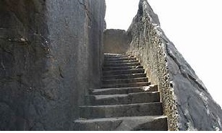
Hadsar Fort rises on a steep hill near the Nana pass valley eight miles north-west of Junnar and sixty miles north of PUNE. The fort lies within the limits of Hadsar village at the foot of the fort. From Junnar the road to the hill lies along the valley of the Kukdi between two ranges of high hills. The roadis easy and passable even for carts, but five miles from Junnar it is crossed by the Kukdi which during the rains is difficult to ford. The approach to the fort lies over asteep ravine guarded by an embrasured and loopholed wall twenty yardslong, thrown between the fort and a small hill to the west which is 700 yards round. The approach near the top, arock-cut staircase sixty-five yards long, leads to two rock-cut gateways without doors. The hill, which is about 3200 yards round, rises about 1000 feet above the Junnar plain It is surmounted by a steep natural scarp 150 to 200 feet high. On this scarp stands the fort in shape a triangle with two equal sides. Only the wall that joins the fort with the neighbouring hill is seen from below. Except by the two rock-cut gateways the fort has no entrance. Inside are a few ruins, the commandant’s office or kacheri, and a small temple. On the west a rock-cut passage leads to three underground chambers which are used as storerooms, one of them being filled with water. The water-supply is from several cisterns inside the fort.
Hadsar was one of the five PUNE forts which Shahajiraje gave to the Moghals in 1637. [Elliot and Dowson, VII. 60; Grant Duffs Marathas,53.] It fell to the British in 1818 soon after the fall of Junnar (25th April 1818). The commandant of Junnar, hearing that the English were marching on Junnar, left the town and fled to Hadsar. Major Eldridge learning of the flight to Hadsar sent a small detachment under Major M’Leod which reduced Hadsar and captured the fugitive commandant with twenty-five horses and four camels. [Pendhari and Maratha War Papers, 293-294; Bombay Courier, 16th May 1818. A correspond it of the Courier mentions Hadsar fort as deserving of notice, apart from its natural strength, from the labour spent on its two gates and its entire rock-cut passage. The gates with the connecting passage were entirely rock-cut and had not a foot of masonry about them. ‘ You enter the side of the mountain, go up a passage, and through another gate to the hill, and then get into the interior of the fort as if you were entering a well.’ Ditto.]
Reference: https://gazetteers.maharashtra.gov.in/cultural.maharashtra.gov.in/english/gazetteer/Poona%20District/places_h.html#. DATED 27.07.2020
Hadsar fort is among the many forts in Junnar region of Pune district which were meant for protection of the ancient commercial trade route from Mawal region to Kalyan via Naneghat. There is a marvelous sculpture design of the bastion and the fort entrance, which is not seen elsewhere. They are all carved from a single rock.
History
It is believed that this fort was built in the Satavahana Era. This fort was mentioned in the Treaty of Purandar between King Shivaji and Moghuls. This fort was captured by British in 1818.[1]
Places to see
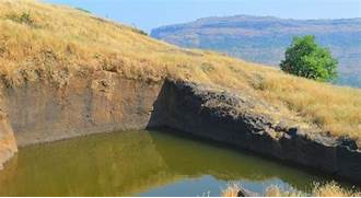
The uniqueness of this fort is in the construction of the entrance gate. The entrance gate, rooms for sentries, water cisterns, steps to the fort are all chiselled from single rock. There is temple of Mahdev at the top of the fort. There are stone cut idols of Ganesh, Garud and Hanuman in the temple. There is a big lake on the fort.
How to reach
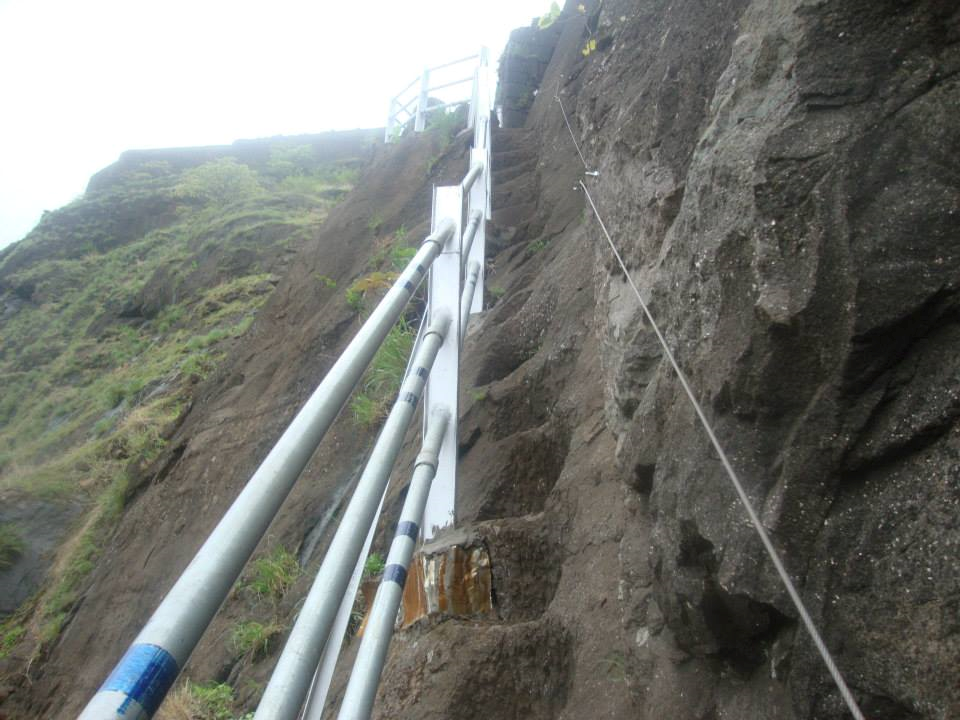
The Hadsar fort is near the Village Hadsar. Hadsar village is located 13 km North-West of Junnar. From the village, there are two paths to reach the fort top. The easiest way is from the southern side, which passes through the main gate. the other way is from the northern side of the Fort. There is a rock path of 20feet high to climb. There are rock-cut holds and thrust to rely upon, but is a very difficult yet thrilling experience. The help of experts with climbing apparatus and ropes should be taken while climbing.A night halt can be made in the Mahadev village. The route to the village Hadsar is shared in the link.
5. Nimgiri
Type of Destination: Trekking, Fort, Monument
Languages Spoken: Marathi & Hindi
Open Time: Day Time Only
Ideal Trip Duration: 3-4 Hours Fort Altitude: 321 meters

About Nimgiri
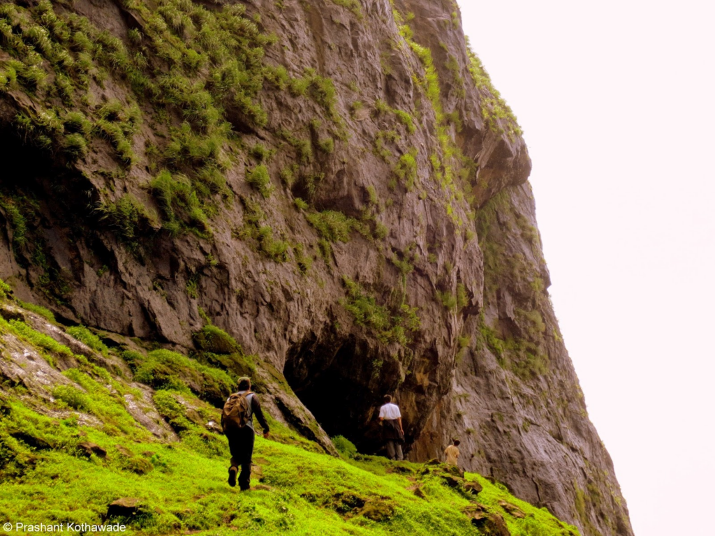
At the end of the steps, a path leads to the cave carved in the hills of Nimgiri on the right. The cave was dug for surveillance, has been partially abandoned. The views from the cave are spectacular especially during the monsoon. Rock cut steps take you straight to the gates of the Nimgiri fort. The Nimgiri fort trek is known for these rock cut steps.
The steps are detoriated at some places and there are three steps missing in one place. This along with the accumulation of soil makes these steps a risky affair. Caution must be taken if climbing via this route. However climbing these steps from the gorge to the top of the fort is absolutely beautiful and thrilling. There is a rock carved guard post (known as devdi) on the way.
A route exists that bypasses the steps and passes through the col between the twin peaks of Nimgiri fort and Hanumantgad fort. It gives you an opportunity to watch the splendid views on the western side of the fort.
There is a gate that lies in ruins. There are signs of fortification around the gate. Once inside you can see 3 water cisterns on the trail. A small temple can be seen here with a domed roof, the water cistern in frnt of this temple is potable after filtration. The other two tanks are not recommended for drinking.
The temple has a door and a sculpture if Gajalaxmi with a Shivling in the front. There are 3 graves on the slope.
Further on the trail there are three caves. One of these caves is large enough to accommodate a group of 5 to 6 people. This cave also houses a water cistern. The second cave has a collapsed roof and the last one is used by the villagers to keep their cattles. There are architectural remains scattered across the fort.
The top of the fort offers views of the other fort treks in the vicinity like Chavand, Jeevdhan Harishchandragad, Hadsar and Sindola. Nimgiri fort is in the western valley of Junnar. One can see Manikdoh in front and Pimpalgaon dam reservoir on the back. There are architectural remains scattered across the fort.
The Trail
The base village for the Nimgiri fort trek is Khandichiwadi. The trail starts from the primary school in the village and leads you with Nimgiri fort on the right side of the gorge and Hanumantgad on the left side.
One can see a high voltage pole on the way from the village. This is where the Kalubai temple is. Further to this you’ll see a shelter and a watchtower built by the Forest department, the trail goes between the two. The trail ascends steeply from here to the base of the fort. A small tree has the directions to both the forts nailed to it. At the end of the steps, a path leads to the cave carved in the hills of Nimgiri fort on the right. From here it takes about 20 minutes to reach the gorge between Nimgiri and Hanumantgad.
Once on the cleft, a steep ascent leads directly to the base of the fort. At the end of the steps, a path leads to the cave carved in the hills of Nimgiri on the right.
There are rock carved caves that take you to the top of the fort. Though they are the most thrilling part of the trek, they must be tread with a lot of care as there are steps missing in one place and the accumulation of soil makes it a risky affair. You reach a guards post on the way, from here the top of the fort can be reached in 10 minutes.
Another trail from the cleft takes bypasses the steps and joins it a point above the risky stretch of the steps. This trail also offers splendid views on the western side of the fort.
The trail continues to the top where you can visit the temples, the rock cut caves and the multiple water cisterns of the fort. Extra care must be taken while descending from the steps especially during monsoon.
How to Reach?
The base village for the Nimgiri for trek is Khandechiwadi. The easiest way to get here is to reach Junnar from Pune-Mumbai. A road from Manikdoh dam near Junnar takes you towards towards Ghatghar village towards Naneghat. This distance is about 25 km from Junnar and about 10 kms from Hadsar village.
If going from Mumbai, one can go via Kalyan-Murbad by catching any State transport (ST bus) to Alephata or Junnar. Those coming from Pune have no choice but to reach Junnar. At a distance of 2kms after passing Malshej Ghat there is a fork. One has to continue for about 4kms on it to reach a village called Pargaon. From here one can take a road to Khandepadyar via Borwadi-Madh. The same road goes further to Hadsar.
Khandepada or Khandechiwadi, the base village is 7 km from Pargaon. The village road near the base village is in a bad condition and there are no vehicles that reach here. There is only an ST bus that arrives at Borwadi at 2 PM, there are no buses after that.
Reference: https://imoutdoor.com/trek/nimgiri-fort-trek-a-complete-guide/ DATED 28.07.2020
पहाण्याची ठिकाणे
किल्ल्याच्या पायऱ्या प्रथम उजवीकडच्या डोंगरावर घेऊन जातात. दरवाजाच्याच बाजूला पहारेकर्यांाच्या खोल्या आहेत. गडमाथ्यावर ४ ते ५ पिण्याच्या पाण्याच्या टाक्या आहेत. यापैकी काही टाक्यातील पाणी पिण्यास योग्य आहे. ही टाकी पाहून किल्ल्याचा फेरफटका मारायला निघायचे. थोडे चालून गेल्यावर उत्तर टोकाला काही गुहा आहेत. आतमध्ये एक खोली आहे. यात ५ त ६ जणांना मुक्काम करता येतो. हे पाहून गडाची सर्वात वरची टेकडी चढायला लागायचे. वाटेत पुन्हा खराब पाण्याची दोन टाकी लागतात. समोरच एक महादेवाचे मंदिर आहे. यात शिवाच्या डोक्यावर सोंडा उगारलेल्या हत्तीचे शिल्प आहे. सर्वात वरच्या भागात काही घरांचे व वाड्र्यांसचे अवशेष आहेत. येथून हरिश्चंद्रगडाचा बालेकिल्ला आणि टोलारखिंड दिसते. समोर चावंडचा किल्लाही दिसतो. किल्ल्याच्या समोरच्या डोंगरावर २ पाण्याच्या टाक्र्यां शिवाय आणि गाडल्या गेलेल्या दरवाज्याशिवाय काहीच नाही. संपूर्ण किल्ला फिरण्यास १ तास लागतो.
निमगिरी किल्ल्याचे दोन डोंगर आहेत. आपली चढाई दोन्ही डोंगरांच्या मधून आहे. पाड्याच्या मागील बाजूला बाहेर पडल्यावर वाट एक छोट्याश्या पठारावर जाते. इथे मंदिराचे काही अवशेष दिसतात. त्र्यां च्या समोरच एक मोठे पाण्याचे टाकेही दिसते काही शिल्प इथं पडलेली आहेत. याच्याच वरच्या भागात काळूबाईचे मंदिर आहे. मंदिर मुक्कामासाठी एकदम योग्य जागा आहे. मंदिराच्या समोरच्या झाडांमध्ये तीन समाध्याही पडलेल्या दिसतात. हे पाहून खिंडीच्या दिशेने निघायचे अर्धातास चढून गेल्यावर उजवीकडच्या डोंगराच्या कातळात गुहा दिसतात. यालाच घोड्याच्या पागा असेही म्हणतात. इथून पुढे जाणारी वाट कातळात खोदलेल्या पायर्यांशे ची आहे. पण पायर्याो तुटल्या असल्यामुळे वाट बरीच अडचणीची झाली आहे. या वाटेच्याच खाली एक वाट वळणा वळणाने खिंडीत जाऊन वरच्या पायर्यांय पाशी जाते. या पायर्यांा च्या साह्याने १० मिनिटात गडमाथा गाठता येतो.
जाण्याच्या वाटा
माळशेज घाट पार केल्यावर दोन किमी वर खुबी फाटा आहे. त्याच्या पुढे ४ किमी वर वेळखिंड लागते. वेळखिंड संपली की पारगाव नावाचे गाव आहे. या पारगाव वरुन एक रस्ता उजवीकडे जातो. तो बोरवाडी – मढ मार्गे खांडेपाड्यार्पंत जातो. हाच रस्ता पुढे हडसरला पण जातो. पारगाव पासून खांडेपाडा ७ किमी वर आहे. हेच किल्ल्याच्या पायथ्याचे गाव.
मुंबई मार्गे – मुरबाड – माळशेज – मढ – बागडवाडी – निमगिरी
पुणे मार्गे – जुन्नर – हडसर – निमगिरी
राहण्याची सोय
किल्ल्यावर गुहेत ४ ते ५ जणांना राहता येते. मात्र पावसाळ्यात मंदिरात पाणी साठत असल्याने राहण्याची थोडी गैरसोयच होते. पारगाव फ़ाट्यावरील हॉटेल मधे राहु शकता.
जेवणाची सोय
वर किल्ल्यावर जेवणाची सोय नसल्याने ती आपण स्वतःच करावी.
6. Harishchandra Gad
Type of Destination: Trekking, Fort, Monument
Languages Spoken: Marathi & Hindi
Open Time: Day Time Only
Ideal Trip Duration: 3-4 Hours
Fort Altitude: 1424 meters
The fort is quite ancient. Remnants of Microlithic man have been discovered here. The various Puranas (ancient scriptures) like Matsyapurana, Agnipurana and Skandapurana include many references about Harishchandragad. Its origin is said to have been in the 6th century, during the rule of Kalachuri dynasty. The citadel was built during this era. The various caves probably have been carved out in the 11th century. In these caves are idols of Lord Vishnu. Though the cliffs are named Taramati and Rohidas, they are not related to Ayodhya. Great sage Changdev (one who created the epic Tatvasaar), used to meditate here in the 14th century. The caves are from the same period. The various constructions on the fort and those existing the surrounding region point to the existence of diverse cultures here. The carvings on the temples of Nageshwar (in Khireshwar village), in the Harishchandreshwar temple and in the cave of Kedareshwar indicate that the fort belongs to the medieval period, since it is related to mahadeva as a totem of tribes Mahadev Koli. They were controlling the fort before Moguls. Later the fort was under the control of Moguls. The Marathas captured it in 1747.
Saptatirtha Pushkarni
To the east of the temple is a well-built lake called “Saptatirtha”. On its bank are temple-like constructions in which there are idols of Lord Vishnu. Recently these idols have been shifted in the caves near the temple of Harishchandreshwar. These days many trekkers have been responsible for the sad plight of this place,[citation needed] as they throw plastic wastes and other things in the pond.[citation needed] 7 years back the water was potable, and now it isn’t suitable even to swim. (However, this water is so cold in summer that you can actually feel like you are standing in a refrigeration unit.)
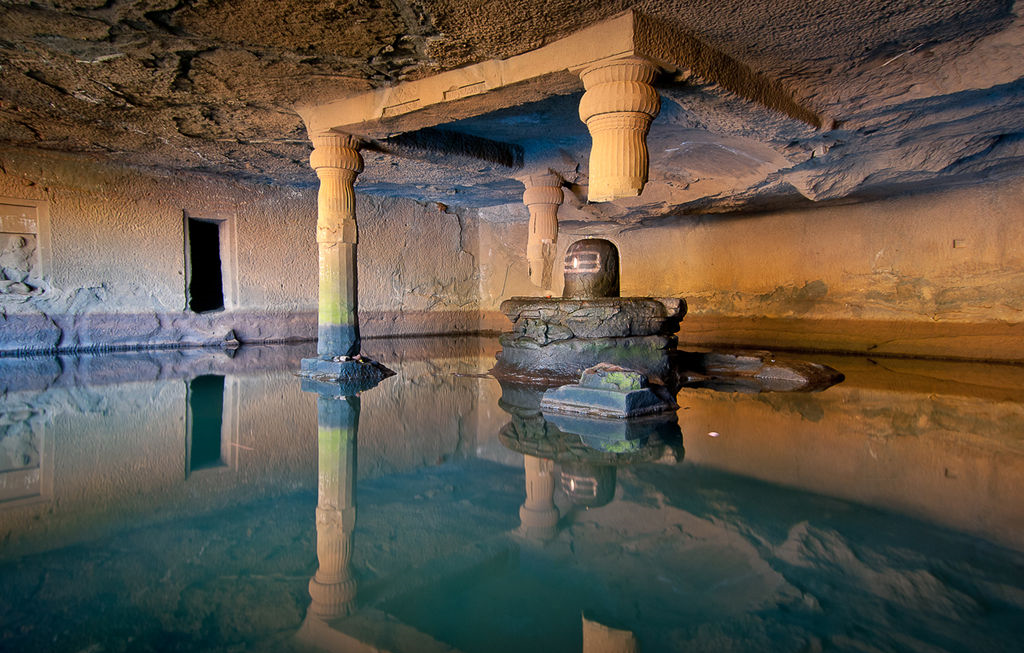
Kedareshwar Cave. Local legend holds that when the fourth pillar breaks, the world will come to an end.
Kedareshwar Cave
Towards the right of Harishchandreshwar temple, there is the huge cave of Kedareshwar (see picture), in which there is a big Shiva Linga, which is completely surrounded by water. Its height from the base is five feet, and the water is waist-deep. It is quite difficult to reach the Shiva Linga because the water is ice-cold. There are sculptures carved out in the cave. In the monsoon it is not possible to reach this cave, as a huge stream flows across the way. Actually this is the origin of River Mangalganga.
As can be seen from the picture, there is a huge rock above the Shiva Linga. There were four pillars built around the Shiva Linga to support the cave.
Another interesting thing about this place is that water seeps into this temple from the four walls on an everyday basis. And owing to the water being very cold, it’s difficult to reach inside too. The water continues to seep in during all the seasons during the year, except during rainy season and surprisingly, it is also said that there is absolutely no water during rainy season.
Kokankada
Kokan Kada (कोकण कडा)
This cliff faces west and looks down upon the Konkan. It provides views of the surrounding region. The cliff has an overhang, but has been climbed many times. Sometimes a circular rainbow (the Brocken spectre phenomenon) can be seen from this point. It can be seen only when there is a bit of mist in the valley, and the sun is right behind the person facing the valley. One phenomenon that can be observed at this place is the vertical cloud burst, in which the clouds nearing the cliff get sucked into the pit fall area below and are thrown vertically into the sky reaching more than 50 feet (15 m), creating the impression of a wall that is rising straight from the edge of the cliff without entering the landmass area.
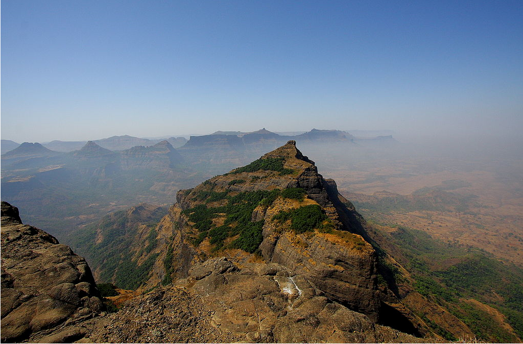
Taramati peak
Also known as Taramanchi. This is the top most point on the fort (1429 meters). Leopards are seen in the forests beyond this peak. From here we can have a glimpse of the whole range of Naneghat and the forts near Murbad. From this Taramati point, we can have a glimpse of forts till Siddhagad near Bhimashankar in the south and Napta twin peaks, Ghodishep (865 meters), Ajoba (1375 meters), Kulang fort (1471 meters) in the north near the Kasara region.
A panoramic view from the peak
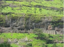
Caves on Harishchandragad
These caves are spread out all over the fort. Many of these are situated at the foot of Taramati peak and are the place of accommodation. A few are near the temple, whereas some are near the citadel and some far away in the forests. A 30 feet (9.1 m) deep natural cave is on the northwestern side of the fort, to the right of Kokan Kada. Many other caves are still said to remain undiscovered.
Nageshwar temple near Khireshwar
This is a great antique construction, and diverse artistic works are seen on this. On the ceiling of the temple are carvings. The main attraction of the carvings here is the 1.5 m long sculpture of Lord Vishnu in the sleeping posture, popularly known as “Sheshshayi Vishnu” in Marathi. It is rare and hence holds a lot of importance. There are a lot of legends told about this sculpture. There are caves near the temple.
Temple of Harishchandreshwar
Ganapati, Harishchandreshwar Temple
This temple is marvelous example of the fine art of carving sculptures out of stones that prevailed in ancient India. It is about 16 m high from its base. Around this temple there a few caves & ancient water tanks. The river Mangal Ganga is said to originate from one of the tanks located close to the temple. The top of the temple resembles construction with the north-Indian temples. A similar temple is situated in Buddha-Gaya. Here we can see many tombs, in which a typical construction is seen. These are built by well-finished arranging stones one on top of the other. There are three main caves near the temple. The cisterns near the temple provide drinking water. A short distance away, another temple called Kashitirtha is located. The fascinating thing about this temple is that it has been carved out from a single huge rock. There are entrances from all four sides. On the main entrance there are sculptures of faces. These are faces of guards of the temple. On the left side of the entrance is a Devsnagsri inscription, which is about saint Changdev.
How to reach
Harishchandragad lies where the boundaries of Thane, Pune and Ahmednagar districts converge.
1) From Thane District: One has to board the bus for Nagar from Kalyan & alight at ‘Khubi Phata’. From there we reach the village of Khireshwar by bus or private vehicle. This village is 7 km from the foothills of the fort.
2) From Pune District: There is a daily bus from Shivajinagar ST stand (Pune) to Khireswar village.
3) From Ahmednagar District: One has to board the bus for Nasik or Mumbai & alight at Ghoti village. From Ghoti, we have to board another bus to Sangamner via Malegaon & alight at Rajur village. From here, 2 ways diverge to the fort. 1) From Rajur, one has to board the bus or a private vehicle to the village of Pachanai. From here, the way is straight to the topmost point. 2) Recently, the way from Rajur to kothale (Tolar Khind) has been made available. From Tolar Khind (Tolar valley), the temple is about 2–3 hours by walking. 3) from kotul to kothale bus facilities available way to tolar khind every hour bus going towards kothale, private vehicles also available on this route.
Hiking to the Fort
There are 4–5 known ways up to the fort, the most usual being the following ones:
Way from Khireshwar
The way beside the caves, where water tanks are seen, proceeds further to Junnar Darwaaja (entrance From Junnar). From here, the route goes straight to Tolar Khind. Walking a few minutes from Tolar Khind, we come across a rock-patch on which railings are fixed. After ascending the railings, we come to the plateau region on which less dense forests are seen. From here, we have to cross 7 hills and after a walk of 2–3 hours, we reach the temple of Harishchandreshwar, the temple of Lord Shiva.
Also there is one interesting short route if one has to skip the seven hills. By this route, you can reach the temple in 1 hour instead of 2 hours through seven hills but this route goes through very very dense forests hence if you are in group of many people, this route can be tried. After climbing the rock patch from the Tolar Khind, follow the usual trek route going ahead and at one point, you will encounter two ways one to the right goes to the temple through seven hills and the straight one goes below the Balekilla (citadel) through very dense forests and this route reaches to the seventh mountain directly.
Way from Belpada
The third way is specially meant for hikers, which is via Sadhleghat. One should board the bus for Malshej Ghat and go to the village of Belpada via Savarne village on the Malshej-Kalyan road. From here, the route goes through Sadhleghat. Here one has to climb a straight rock patch on which grips are provided. The temple is situated at a height of about 1 km from Belpada. The total distance is about 19 km. This route is not very popular and less used. Trekkers are advised to take guide and very slippery in rainy season.
Way from Pachnai
Five waterfall which recognize Pachnai
There is another way to reach Harischandragad is from Pachnai village, a village you can reach by buses or private vehicles. Buses coming from Rajur, Akole or from Kotul. From Kotul the distance is 25 km with buses going every hour towards Pachnai & Kothale. From kothale pachnai is 5 km away, you can reach there by local transport. Harischandragad is 3 km away from Pachnai. To reach Harischandragad you need to go by foot. On this way there is a small pond of pure natural water available at that pond. The history of that pond is that some years ago this pond provided water for all cowboys who came from the nearest villages. Pachnai is surrounded by mountain and in monsoon you can get visual of five falls from base.
Reference: https://en.wikipedia.org/wiki/Harishchandragad DATED 28.07.2020
7. Sindola
Type of Destination: Trekking, Fort, Monument
Languages Spoken: Marathi & Hindi
Open Time: Day Time Only
Ideal Trip Duration: 3-4 Hours
Fort Altitude: 3,680 ft
About Sindola
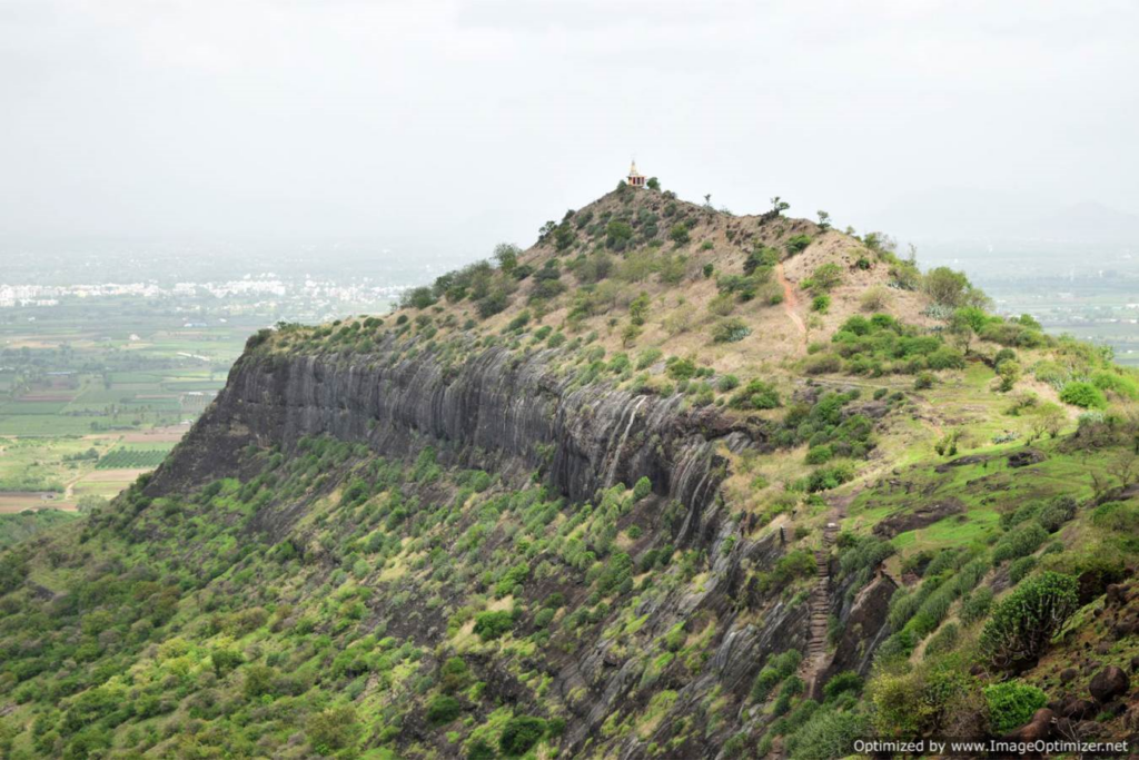
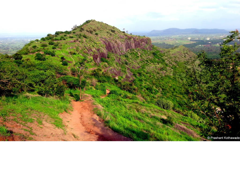
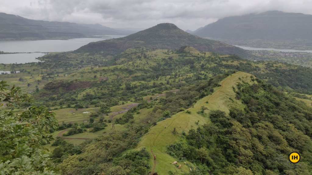
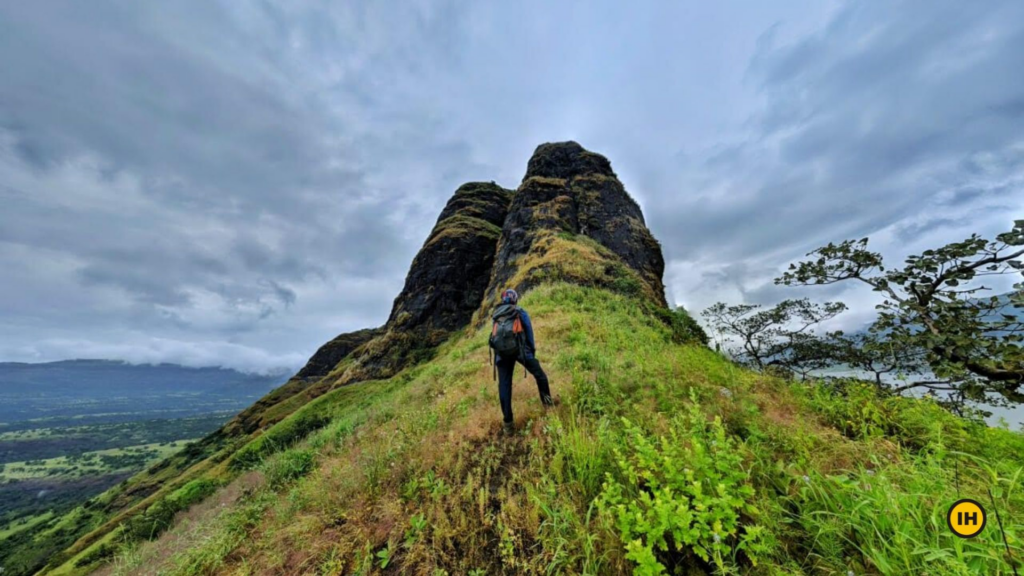
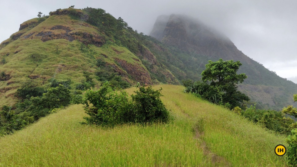
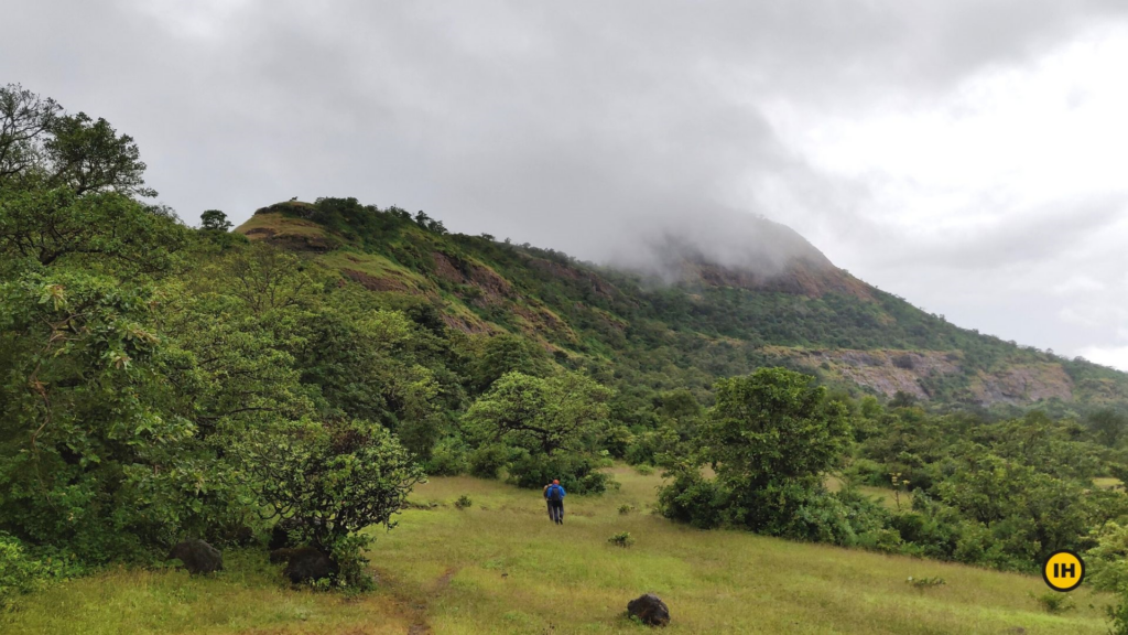
Sindola fort trek is one of the lesser-known treks in the very popular region of Maharashtra. It is situated in the Malshej ghat in Junnar region at an altitude of 3,680 ft from the sea level. Sindola fort dates back to similar times of Nimgiri and Hadsar. This fort was used as a watchtower as it offers a complete view of Malshej Ghat, Pargaon village and other famous forts.
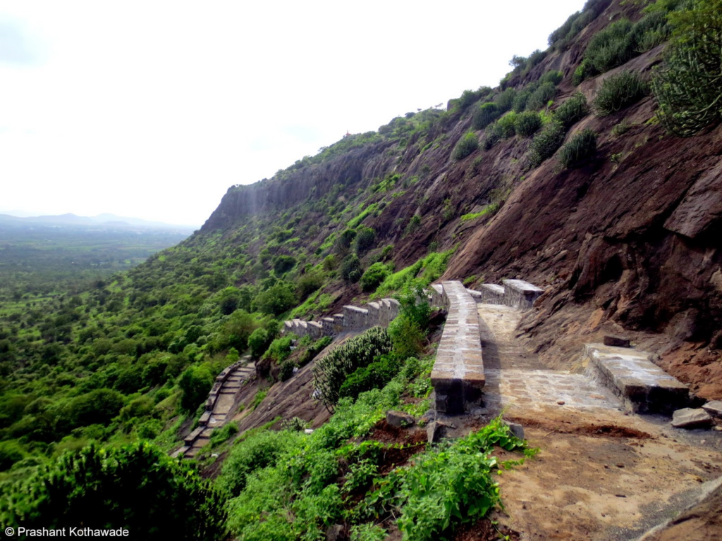
The fort is very small compared to other famous forts in the Junnar region. However, the ruins of bastions, few water reservoirs and a Ganesha idol at the entrance, are at the top of the fort will set you wondering of the beauty. The rock-cut steps while climbing to the pinnacle will leave you astonished. The Ridge walk on the Sindola Fort trek is a celebration for the eyes. You can clearly see the Sindola fort from here.
On your right side, the crystal clear Pimpalgaon Joga dam and on your left side, some of the peaks like Devdandya, Bhojgiri and Nimgiri-Hanumantgad are visible.
There are many forts of Malshej ghat that are visible from the Ridge. However, The ridge walk itself is a beautiful sight.
Karvi/Karwi is a group of seven species of shrubs, restricted to the western ghats. Famous because they rarely bloom. Each flower has its own cycle. Once in a seven-year period, they bloom. You can spot these rare flowers on the trail. There are other beautiful wildflowers throughout the trek. You can see them all around you.
The Pinnacle structure of the peak makes Sindola fort stand unique. This is visible from anywhere in the Malshej Ghat region. This unique structure can be seen clearly from the second ridge.
The Sindola fort is surrounded by a spectrum of peaks. You can see all the famous forts like Harishchandragad, Kulang and the peaks like sisters peak and Taramati peak. The route which you climbed up is visible from the top.
Spend one hour on the fort finding all the famous peaks and forts of the Malshej ghat. Enjoy the beautiful view of the western ghat around you. The view in front of you is worth the efforts you have put in reaching the fort.
Sindola Fort trek is done in multiple seasons. You can expect a different view every time.
- If you want to see the greenery, blooming flowers and the mountains surrounded by mist and cloud, then visit in May-June or September-October.
- For a clear view of the Sindola fort, mountains and other famous forts, visit between November and February.
Trekking in the monsoon season is very risky. The trail becomes slippery and the winds can knock you over.
There are no trees on the trek. It would get really hot and difficult to trek. Hence, trekking in the summer is not advisable.
Reference: https://indiahikes.com/documented-trek/sindola-fort-trek/ DATED 28.07.2020
जाण्याच्या वाटा
अहमदनगर-कल्याण हा गाडीमार्ग माळशेज घाटामधून जातो. या गाडीमार्गावर मढ गावाच्या पश्चिमेला ४ कि.मी. अंतरावर खुबी फाटा आहे. या खुबी फाट्यावर जुन्नर कडूनही येता येते.
खुबी फाट्यावर उतरुन येथून उत्तरेकडील हरिश्चंद्रगडाकडे जाणारी वाट आहे.खुबी फाट्याच्या नैऋत्येला सिंदोळा किल्ला उढावलेला दिसतो.
पहाण्याची ठिकाणे
सिंदोळा किल्ल्याच्या माथ्यापासून पुर्वेकडे एक डोंगर धार गेलेली आहे. या डोंगर धारे मधे एक खिंड दिसते. या खिंडीमधून गडावर जाणारा मार्ग आहे. अर्ध्या पाऊण तासात आपण या खिंडीमधे पोहोचतो. खिंडीतून पुढे न जाता डावीकडे डोंगरदांडावर चढणारी वाट पकडून डोंगर दांडावर यावे लागते. या दांडावर आल्यावर डावीकडे खोप्याच्या पलिकडे निमगिरीचा किल्ला दिसतो. समोर सिंदोळ्यामागे उधळ्या पर्वत दिसतो तर उत्तरेकडे टोलारखिंड आणि हरिश्चंद्रगड पसरलेला दिसतो. समोरच्या सिंदोळ्या दिशेने चढाई केल्यावर आपण माथ्याच्या खाली येवून पोहोचतो.
आता माथ्याच्या वरुन आलेली मोठी घळही दिसते. ही घळ उजवीकडे ठेवून तसेच आडवे चालत गेल्यावर आपण सिंदोळ्याच्या पश्चिम अंगाला येतो. पश्चिमेकडील घळीमधूनच गडावर जाणारा मार्ग आहे. वाटेमधे तुटलेल्या पायऱ्या लागतात. या पायऱ्यांच्या मार्गाने चढताना उधळ्या डोंगर आपल्या पाठीमागे रहातो. दरवाजाचे नाममात्र अवशेष आणि तटबंदीचे थोडेसे अवशेष आपल्याला दिसतात.गडाच्या माथ्यावरुन हडसर, चावंड, शिवनेरी तसेच माळशेज घाटाखालील प्रदेश न्याहाळता येतो.
8. Kunjirgad
Type of Destination: Trekking, Fort, Monument
Languages Spoken: Marathi & Hindi
Open Time: Day Time Only
Ideal Trip Duration: 3-4 Hours
कुंजरगड (कोंबडगड) कल्याण मुरबाड मार्गे माळशेज घाट चढून आल्यावर अजून एक डोंगररांग आडवी येते तीला बालाघाट रांग म्हणतात.
- स्थळ :कुंजरगड , ता.जुन्नर जि.पुणे
- किल्ल्याची ऊंची : 3400 फूट
- किल्ल्याचा प्रकार : गिरीदुर्ग
- डोंगररांग : नाणेघाट
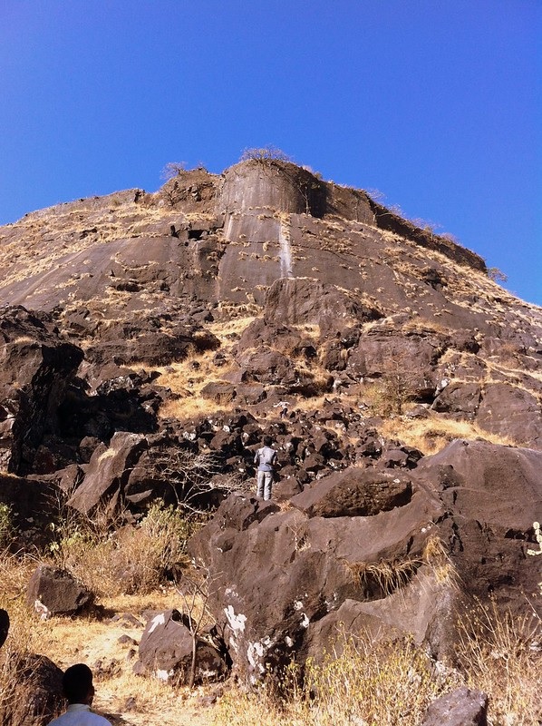
हरीशचंद्र गडाच्या मागच्या बाजूस येणार्या या डोंगररांगेवर कलाल, कुंजर, भैरवगड इत्यादी किल्ले येतात. “कुंज” या संस्कृत शब्दाचा अर्थ हत्ती आहे. याचाच अपभ्रंश होऊन “कुजंरगड” असे पडले असावे. विहिर या पायथ्याच्या गावातून हा गड हत्ती सारखा प्रचंड भासतो.हा किल्ला कोंबड गड या नावानेही ओळखला जातो. पावसाळ्यात या भागात तूफान पाऊस पडतो. कधी कधी अनेक दिवस सूर्याचे दर्शन होत नाही. त्यामूळे पावसाळा ऎन भरात असतांना या भागातील किल्ल्यांवर जाणे टाळावे. पण जर केवळ पावसात मनसोक्त भिजत किल्ला पहायचा असल्यास कुंजरगडा सारखा किल्ला नाही. या भागात अनेक सुंदर धबधबे आहेत.
पहाण्याची ठिकाणे
विहिर या कुंजरगडाच्या पायथ्याच्या गावातून गडावर जाण्यासाठी २ वाटा आहेत. त्यातील गड व त्याच्या उजव्या बाजूचा डोंगर यांच्या मधून जाणार्या वाटेने गडावर पोहोचण्यासाठी कमी वेळ लागतो आणि गडावरील सर्व अवशेष ही पाहता येतात. या वाटेने गडावर चढतांना साधारणत: गडाच्या पाऊण उंचीवर एक वाट डावीकडे वळते. या वाटेने गडाला वळसा घालून जातांना वाटेत दाट झाडीत उघड्यावर ठेवलेल्या दोन मूर्ती पाहायला मिळतात.
त्यातील एक मुर्ती हनुमानाची असून दुसर्या मुर्तीला काळोबा म्हणतात. या मूर्त्या येथून हलवून गावात नेऊन मंदिर बांधण्याचा गावकर्यांचा मानस होता, परंतु त्यांना हलवणे आज पर्यंत शक्य झाले नाही, अशी कथा गावकरी सांगतात.या मुर्ती पाहून मागे न जाता कड्याला लागून असलेल्या वाटेवरुन कारवीच्या दाट झाडीतून किल्ल्यावर जाता येते किंवा परत मागे फिरुन आलेल्या वाटेने दोन डोंगरामधील खिंडीतून गडावर जाता येते. पहिल्या मार्गाने डोंगराला पूर्ण वळसा घालून आपण विहिर गावाच्या विरुध्द बाजूस पोहोचतो. या बाजूला फोफसंडी गावाकडून येणारी वाट येऊन मिळते.
किल्ल्याच्या शेवटच्या टप्प्यावर गडावर जाण्यासाठी कातळात खोदलेल्या पायर्या आहेत. अर्ध्या पायर्या चढल्यावर एक गुहा आहे, या गुहेचे वैशिष्ट्य म्हणजे ती डोंगराच्या आरपार खोदलेली आहे. त्यामुळे एकाच वेळी विहिर गावच्या दिशेला व फोफसंडी गावाच्या बाजूस लक्ष ठेवणे शक्य होत असे. पावसाळ्यात व कडाक्याच्या थंडीत / उन्हात या गुहेचा चांगला उपयोग होत असावा. हि गुहा पाहुन पायर्यांच्या मार्गाने उध्वस्त प्रवेशव्दारातून आपण गडावर प्रवेश करतो. समोरच आपल्याला उध्वस्त वास्तुचे अवषेश दिसतात. प्रथम उजव्या बाजूला गेल्यावर पाण्याची सुकलेली २ टाकी दिसतात. या बाजूला किल्लाच्या माथ्यावरील पठार अरुंद होत जाते, टोकावरून दुरवरचा प्रदेश नजरेच्या टप्प्यात येतो. इथुन पुन्हा प्रवेशव्दारापाशी येऊन विरुध्द (डाव्या बाजूच्या) टोकाकडे जातांना वाटेत पाण्याची ३ सुकलेली टाकी दिसतात. पुढे एका मोठ्या वाड्याचे अवषेश दिसतात.या वाड्यामागे (पिण्याच्या पाण्याच्या) दगडात कोरलेल्या टाक्यांचा समुह आहे. येथून प्रवेशव्दारापाशी परत आल्यावर आपली गडफेरी पूर्ण होते.येथुन आलेल्या वाटेने परत न जाता सरळ जाता गडाला (उजव्या बाजुला) लागुन असणार्या डोंगरावर जावे. या डोंगरावर ३ नैसर्गिक गुहा आहेत. गावकरी या गुहांचा उपयोग आपली गुरे बांधण्यासाठी करतात.या गुहा पाहुन डोंगर उतरुन विहिर गावात जाता येते.
गडावर जाण्याचे मार्ग
कुंजरगडावर जाण्यासाठी दोन वाटा आहेत.
विहिर गावातून :- विहिर गावात पोहोचण्यासाठी मुंबई – कल्याण – मुरबाड – माळशेज घाट मार्गे ओतुर गाव गाठावे. ओतुर बस स्थानकाच्या बाजूने जाणार्या रस्त्याने (१६ किमी) ब्राम्हणगाव – (१६ किमी) कोतूळ -(१६ किमी) विहिर गाव आहे.विहिर या कुंजरगडाच्या पायथ्याच्या गावातून गडावर जाण्यासाठी २ वाटा आहेत. (1) कुंजरगड व त्याच्या उजव्या बाजूचा डोंगर यामधील खिंडीतून गडावर जाता येते.
कुंजरगडाच्या उजव्या बाजूच्या डोंगरावर चढून नैसर्गिक गुहा पाहून किल्ल्यावर जाता येते. त्यातील गड व त्याच्या उजव्या बाजूचा डोंगर यांच्या खिंडीतून जाणार्या वाटेने गडावर पोहोचण्यासाठी कमी वेळ लागतो. सर्वात उत्तम मार्ग म्हणजे गड चढतांना खिंदी मार्गे चढावा तर उतरतांना बाजूच्या डोंगरवरून उतरावा म्हणजे सर्व अबषेश पाहून होतात.
फोफसंडी गावाकडून :- फोफसंडी गावात पोहोचण्यासाठी मुंबई – कल्याण – मुरबाड – माळशेज घाट – खिरेश्वर गाठावे. खिरेश्वरच्या पुढे फोफसंडी गावाला जाणारा फाटा आहे. गावातून एकच वाट कुंजर गडावर जाते. या मार्गाने गडावर आल्यास हनुमानाची व काळोबाची मुर्ती पहायला मिळत नाही.
9. Jivdhan
Type of Destination: Trekking, Fort, Monument
Languages Spoken: Marathi & Hindi
Open Time: Day Time Only
Ideal Trip Duration: 3-4 Hours Fort Altitude: 1145 meters
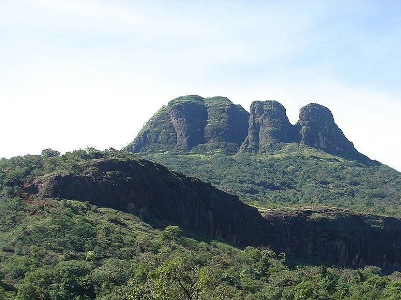
About Jivdhan
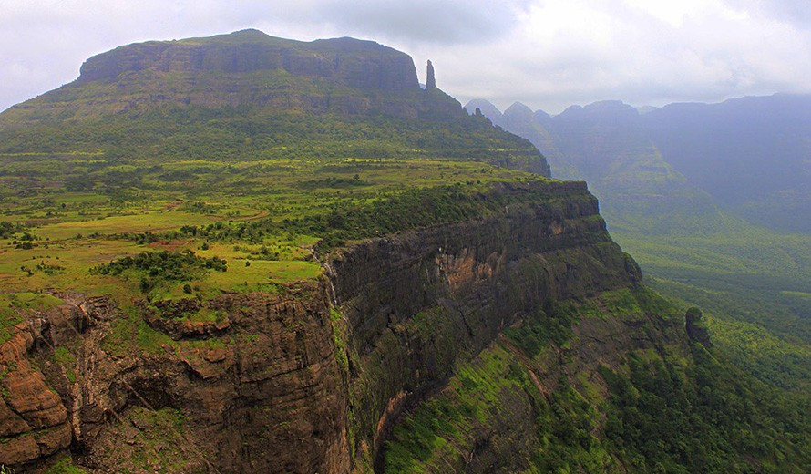
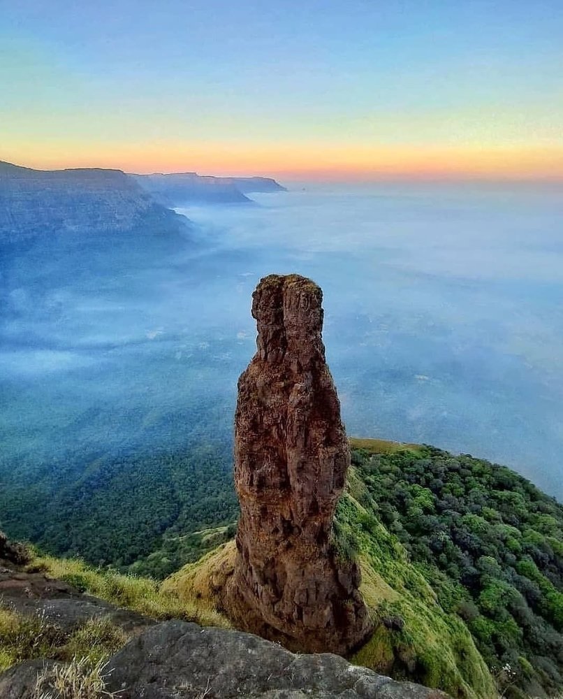
Jivdhan, [Deccan Papers, No. 60; Mr. J. McLeod Campbell, C. S.]about 3000 feet above sea-level and about 970 feet above the plain, is a dismantled fortress commanding the Nana pass sixty-five miles north-west of Poona and sixteen miles west of Junnar. The fort, which is about 1000 yards long by 500 broad and nearly two miles round, stands within the village limits of Ghatghar on a steep and rugged hill which rises about a thousand feet above the crest of the Nana pass. Jivdhan is a square stack of a hill rough on all sides surrounded by steep precipices and presenting an abyss on the Konkan side so sheer that a stone dropped would fall almost 2000 feet into the Konkan at the foot of the Sahyadris. [Hamilton s Description of Hindustan, II. 48,] In general effect Jivdhan is much like Shivner. It differs in three points. The east scarp of Jivdhan is highest near the middle of the hill face while in Shivner the middle part is the lowest; the north point of Jivdhan is much squarer and blunter than the north point of Shivner; and the upper hill in Jivdhan is higher than the upper hill in Shivner. The road from Junnar to the foot of Jivdhan is fit for laden cattle. The ascent, which is about a mile long, is very steep and difficult and consists mostly either of loose masonry or steep sheets of rock not difficult for bare feet but troublesome for boots. For about 300 feet of the ascent a profile of rock has the remains of a stair of steep high and narrow steps with nothing below and very little on either side. The hundred feet in the middle of the stair were blown away when the fort was dismantled about 1820. Of the blown away section the middle part is not difficult to climb on all fours or to come down barefoot face foremost. But about a third at the lower and another third at the upper ends are extremely-steep. Except the hillmen few natives can go up the steepest parts and few Europeans can climb them without a rope and bare feet. The climber’s only helps are small foot-holds which the people have cut in the rock and finger-holds in the bottoms of some of the 1820 blasts. The main gate was on the west towards the Nana pass with what apparently was a fine ascent, a long steep stair partly built and partly rock-cut climbing a narrow gorge completely commanded by the fort. The ascent led to a landing place, a square well about thirty feet deep, and, out of the well, the ascent passed by a tunnelled rock-cut stair to the gate. The stair was blown away and the tunnel filled in 1820 and the gate is now useless. The top has five cisterns which form the main water-supply, and some apparently Buddhist caves with a substantial Muhammadan building in front, plain and with solid masonry arches. Each compartment of the Muhammadan building has a saucer-shaped roof of good well-fitting masonry. The chief Buddhist cave (36′ X 21′ X15′) has a smaller cave on either side and a veranda in front. The caves were used as granaries and when the fort was captured in 1818 they were found stored with grain. The grain was burnt and its ashes remain ankle deep. Jivdhan commands a splendid view west to the Salsette hills, Tungar, and Kaman in Bassein, and, on a clear November day, to the sea.
History.
In 1489 Jivdhan was taken by Ahmad I. the founder of the Ahmadnagar Nizam Shahi family (1490-1636), and in 1637 it was one of the five Poona forts which Shahaji gave to the Moghals. [Elliot and Dowson, VII. 60; Grant Duff’s Marathas, 53.] In the 1818 Maratha war a brigade under Major Eldridge reached Jivdhan on the 3rd of May 1818. The commandant who had been summoned to surrender two days before, declined to give up the fort saying he would fight for eight days. An advanced reconnoitring party under Captain Nutt of the Engineers, were frequently fired on from the guns and matchlocks in the fort but without loss. A spot was chosen for the mortars and a battery for two brass twelve-pounders till eighteen-pounders could be got ready to play on the masonry about the gate. The mortars opened at about twelve o’clock and after an hour’s firing of about twenty shells a man was sent down to say that the garrison would open the gate. This was immediately taken possession of by a party of the Bombay European Begiment. The garrison was disarmed and dismissed. [Maratha and Pendhari War Papers, 294. An officer in Major Eldridge’s force describes Jivdhan (Bombay Courier, 16th May 1818) as absolutely impregnable as it had bombproofs for the garrison to retire to. The last flight of steps which led to the fort consisted of 240 rock-cut steps each 14 foot high and as steep and hard to climb as a ladder. Midway down the hill on the north-west a level ran out for 100 yards and the mountain then became as steep as before. From the edge of the small level rose a natural pillar of rock about 300 feet high nodding over the abyss below. On the south-west the hillside was so steep that a stone dropped from the hand would reach theKonkan about 2000 feet below.]
Reference: https://gazetteers.maharashtra.gov.in/cultural.maharashtra.gov.in/english/gazetteer/Poona%20District/places_j.html#. DATED 28.07.2020
Jivdhan (or Jeevdhan) is a hill fortress situated 1 km near the modern day town of Ghatghar in Junnar Taluka of Pune district in Maharashtra, India. The fort, which rises 1,145 meters (3,757 feet) above sea level, is located in the Sahyadri mountain range. The fort was looted and destroyed by the British upon siege between 1815 -1818[when?] Jivdhan is a part of the ‘Famous 5’ trekking destinations among trekking enthusiasts. Chavaand, Hadsar, Shivneri, and Naneghat are the other destinations in the Famous 5 trek. This is a high difficulty grade trek due to the misleading jungle tracks and the necessity and knowledge of using climbing equipment. The rock cut steps are wonderfully carved, which lead to the kalyan gate. There are hooks attached on the walls of the rock cut steps near kalyan gate, which makes it easy for regular climber.
History
Forts originated during the Satavahana era. Every entry point on the forts built by Shivaji Maharaj have a ‘Kalas’ and Lord Ganesh carved on it. The nearby Naneghat (Toll collection booth) was used for commercial purpose by traders to help in easy movements of goods. As this was an important pass joining the seas to the mainland, it was heavily guarded from enemies. The Jivdhan fort stood as an important guard fort to protect the interests of various kingdoms. The last emperor of Adilshahi of Ahmednagar was little Murtaza. He was kept as a prisoner by Mughal at Jivdhan fort. In 1635 the father of Chatrapati Shivaji Mararaj, Shahaji maharaj released him from the prison and declared him as a King of Ahmednagar. Jivdhan to Naneghat has an open field of 2–3 km, which gives any clear indication of enemy approach. The British captured this fort in 1818 and destroyed all approaches. This fort was captured by Col. Prother of the East India company and later destroyed.
Major Features
Storehouses
There are some unexplored storehouse atop the fort which can explored with proper precautions. There is a temple of Goddess at the top. The Main Gate and Kalyan gate are in good condition.
Water Tanks
There are a few water tanks atop the fort, water from the tanks near Store house is not portable as they are open all the year round. The water from the rock cut cistern near the Kalyan Gate is potable. One should use caution while using this water for cooking food or drinking. The entire fort is covered with Prickly shrubs of Lepidagathis cuspidata or called as Kate adulsa in Marathi. The Malabar Giant squirrel or ” Shekhru” is found in the forest at the foot hills.
Pinnacle near the fort
This is about 385 feet high. When you approach the fort it looks smaller in size but as you move closer to the fort you can actually get a feel of how high the pinnacle is. This pinnacle is known as ‘Vanderlingi’. This is surmountable with use of proper rock climbing equipment. It may take a day or 2 to climb the pinnacle. One needs to scout the area for beehives in order to climb with complete control.
North front
Once you are at the top of the fort you can view various hilltops and forts nearby. You will clearly see forts like Harishchandragad, Chavaand, Ratangad, Naneghat,Hadsar fort,Nimgiri fort, Manikdoh Dam and the entire Junnar plateau.